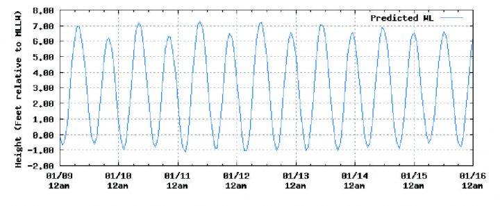
Here on the Southeast Georgia Coast, the tide is not only everything, it’s the biggest thing. Literally. We have the biggest tide swings on the East Coast, besides a few spots off the Coast of Maine. For fisherman, this can be a hard nut to crack. Without going into a whole lot of science, as a rule, the tide changes every 6 hours. The amount of water moving during these six hour periods is a key factor. Generally, an average tide will move about 6 ½ feet of water from low to high, and high to low. I say generally, because as we approach different moon phases, the amount of water pushed in, and the amount of water pulled out changes. Remember, these amounts of water only have 6 hours to fill, and 6 hours to empty. (Low to high, high to low, etc.) Depending on the amount of water being pushed in or out, the current will either be stronger or weaker. The weaker flow, or amplitude, is usually not a problem. On the other hand, when larger volumes of water are moved, the current runs swifter, and the water becomes very turbid, or just plain dirty, as mud and sediment are picked up by these stronger flows. Fish hate this! As a rule the periods around the full and new moons pull harder, and conversely, the periods furthest away from the full and new moons pull slower. Fortunately, or unfortunately not all moon phases during the year follow an exact pattern, so predicting clean or dirty water can be tricky. I like to refer to a tide chart that shows the tide stage (or height, or lack of) at both low and high.
I use saltwatertides.com. This site will let you look at tides for the whole year and years to come. The low is always based on 0.0, and the high is actual tide height, depending on where in the tidal system you may be located. To make things simple, as a rule, I shy away from tides that move more than a total of 7.9 feet. For example, if low tide at the St Simons Sound is predicted at a height of 0.5 and the high tide is predicted to be 6.7, I have a total movement, or flow of 6.2. This falls well below 7.9, and means clean fishable water. If low tide height is listed at -1.1 (notice the negative indicating lower than avg., avg. low being 0.0) and the high is listed at 7.6, the water will move 8.6 feet during that period, well above the 7.9, causing dirty water. I know the best time to go fishing is when you can, but for those with a little luxury to plan a fishing trip, picking tides that have clean water will definitely contribute to a successful fishing here in the Golden Isles.
Capt. Tim Cutting
Coastal Georgia Inshore Charters
St Simons Island, Georgia
912-230-1814