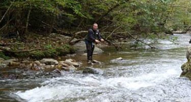
 Get away from the crowded rivers and streams and come to the mountains of Western North Carolina in Madison County just north of Asheville. You’ll find pure water quality in the many fly fishing creeks with diverse stream conditions — from trout streams with pools to the broader rivers like the Shelton Laurel. Fish on the mighty French Broad River with its smallmouth bass, catfish and muskie. Traveling into the back roads of the county brings you closer to the natural environment creating a sense that you are a part of the mountains. The meandering path of the waters lends itself to the solitary nature of the sport.
REGULATIONS:
Anglers must have appropriate licenses and permits to fish for trout in North Carolina. These may be purchased from authorized private businesses that contract with the NCWRC. State fishing licenses are required for all fisherman 16 years old and up. Licenses must be carried by fishermen at all times when fishing. Rules and regulations regarding trout fishing are available at businesses throughout the county. For more details: http://visitmadisoncounty.com/fishing
 STOCKED TROUT STREAMS:
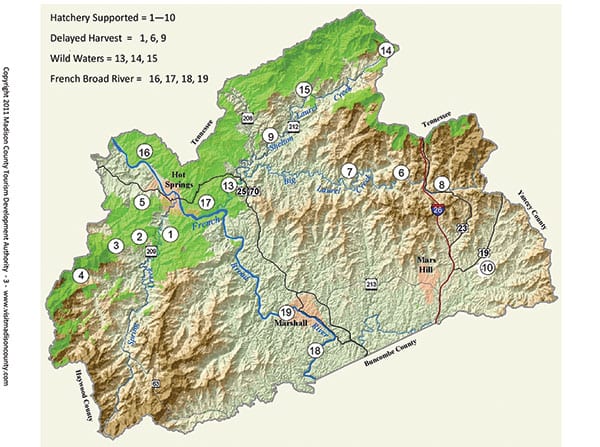
1. Spring Creek
From Hot Springs, take Highway 209 for about 7 to 8 miles to the Bluff Community (marked by a sign). The fishing area continues and parallels the highway to the point it intersects with Highway 63. (Also Delayed Harvest)
2. Meadow Fork Creek
From Hot Springs, take Highway 209 for about 7 to 8 miles to the Bluff Community (marked by a sign). Turn right at Meadow Fork Road at the sign that says “Max Patch 10 miles.” The Creek parallels Meadow Fork Road.
3. Roaring Fork & Little Creek
From Hot Springs, take Highway 209 for about 7 to 8 miles to the Bluff Community (marked by a sign). Turn right at Meadow Fork Road at the sign that says “Max Patch 10 miles.” Roaring Fork Road (which is a dead end) is a right turn off Meadow Fork Road and Little Creek Road is a left. The creeks parallel each of the roads.
4. Max Patch Pond
From Hot Springs, take Highway 209 for about 7 to 8 miles to the sign for Max Patch. Turn right onto Meadow Fork Road. Follow the signs for a left onto Little Creek Road and follow the signs to Max Patch Bald.
5. Upper Shut-In Creek
Drive north from Hot Springs on Hwy 25/70 toward Tennessee. Turn left at Shut In Road, which is the second paved road on the left. The creek parallels the road.
6. Big Laurel Creek
From I 26, take Exit 3. Turn right at the end of the ramp onto Bear Branch. At the stop sign, turn left onto Highway 23 A and follow it for approximately 3 tenths of a mile. Then turn left onto Big Laurel Road, which puts you at fishable waters. Big Laurel Road parallels Big Laurel Creek for approximately 9 miles and then leaves the stream and goes on to intersect with Hwy 208 at the community of Belva. Big Laurel flows through a gorge for about 4 miles before emptying into Laurel River about one mile west of Belva. (Also Delayed Harvest)
7. Spillcorn Creek
Follow the instructions above to Big Laurel Creek and watch for the right turn onto Spillcorn Road which is a little over one mile past the intersection with Walnut Creek Road.
8. Puncheon Fork Creek
From I 26, take Exit 3. Turn right at the end of the ramp onto Bear Branch. At the stop sign, turn right onto Highway 23 A, then left on Laurel Valley and then the first left at Ebbs Chapel Community center. The creek parallels Puncheon Fork Road.
9. Shelton Laurel Creek
From Marshall, take 25/70 North to Hwy 208. Continue on Hwy 208 to the intersection with Hwy 212 and turn right on Hwy 212. The creek parallels the highway. (Also Delayed Harvest)
10. Little Ivy Creek
From I 26, take exit 9. Take Hwy 19 east for about a mile. Turn right on Beech Glen Road and follow it to the intersection with Paint Fork Road. Continue straight on Beech Glen Road where the creek parallels the road.
“WILD” WATERS:
13. Laurel River Trail
At the intersection of Hwy 25/70 and Hwy 208 (GPS: 35.54 and 82.45) there is a parking area located just below the bridge going to Hot Springs. The Laurel River Trail is well marked from the parking area.
14. Big Creek
From Marshall, take Hwy 25/70 north to Hwy 208. Continue on Hwy 208 to the intersection with Hwy 212 and turn right on Hwy 212. The left turn onto Big Creek Road is almost to the Tennessee border.
15. Hickey Fork
From Marshall, take Hwy 25/70 north to Hwy 208. Continue on Hwy 208 to the intersection with Hwy 212 and turn right on Hwy 212. Continue south for 6.7 miles to the sign for Hickey Fork.
FRENCH BROAD RIVER
16. Murray Branch Area
From Hot Springs, take NC Highway 25/70 south and east over the French Broad River. Turn left on River Road and go 4.2 miles to the US Forest Service’s Murray Branch Recreation Area
17. Stackhouse to Hot Springs
From the end of Stackhouse Road off Hwy 25/70 between Marshall and Hot Springs, go along the bank of the French Broad River or use a raft or boat to Barnard Road or Hot Springs where there is no access along the road.
18. Marshall to Buncombe County
From the town of Marshall, drive south along NC Hwy 251 from Marshall to the Buncombe County Line. There are several places to pull off the road for parking.
19. Blannahassett Island
From the town of Marshall, drive south on Bailey Branch Road across the French Broad River and turn right onto Blannahassett Island just after leaving the bridge. There is a fishing pier on the south end past Marshall High Studios (the old school building).