
By Joe Woody
Where do I begin? I could start with a diatribe about the constant struggle to keep our wild places secret and protected or how people who talk publicly about said places are privately and publicly ridiculed by our self-appointed Wild Place Protection Possies (WPPP’s). I’m not ridiculing the WPPP; in fact, they are an honorable people who want our secret places to remain secret. I just needed to give this group a name for the article.
I could also start with a description of my sincere love of storytelling and how I love to describe the journey into wild places in our mountains to the reader. The planning of the trip, the logistics involved, the adventures involved in getting to the stream…the bears…the people…the broken bones and twisted ankles. The whole story would inevitably reveal the location of the wild place, thus placing myself and my publication in direct confrontation with the WPPP.
As you can tell by the dilemma described above, I’m internally conflicted.
In the Stanley Kubrick masterpiece, “Full Metal Jacket”, a gruff Colonel asked the main character, Joker, “How can you write ‘Born to Kill’ on your helmet and wear a peace symbol on your body armor?”. Joker responds, “I think I was trying to suggest something about the duality of man…Sir.”
Now I’m not claiming that my dilemma is as devastating to the soul as Joker’s. I’m just pointing out that there is a conundrum involved.
Since I’ve gotten that off my chest, how do I write a story about a recent fishing adventure to a pristine wild place without giving away the location and name? Should I speak freely about the place or appease my own internal need to protect our areas described by Kephart as the “Back of Beyond”?
I will attempt to do both. Hopefully I won’t fail miserably. I’ll call it…
Adventures in a Place That
Can Not be Named
Let those who can figure it out
do what they will.
So here goes…
I’ve always had a passion for maps. When I was a youngster, I was lucky enough to have wall size world map in my room. I would spend hours studying every nook and cranny of mountain ranges and islands in faraway places. I would then imagine myself standing on top of that mountain or on the coast of that island.
I’ve been lucky enough due to my military and contracting life to have traveled to some of those places I used to dream about. Some places lived up to the hype. Hawaii, The Nile River, Tanzania, The Hindu Kush, to name a few, could be breath taking… others not so much.
When I retired from the Army and moved to the Smoky Mountains, I inadvertently found myself living in the middle of a masterpiece. Although I was born just down the Blue Ridge in Upstate South Carolina, I was unaware of the beauty and adventure waiting for me just over the horizon in Western North Carolina and East Tennessee. I had landed in the place I had searched for all my life without knowing it.
My love of trout fishing and exploration combined. I gathered up my camping gear, fishing vest and 4-piece fly rod and hit the trails. I spent years wandering through our mountains looking for wild trout. The further back in the back of beyond the better. My exploring became almost an obsession. I would spend days at a time either alone or with my fishing buddies Ben Bailey and Barry Holcombe. Sometimes all three of us would take off and go. It’s tough to find fishing buddies…I’m a fortunate man.
In my explorations, there are few sections of streams in the Smoky Mountains that have eluded my footprints and fly rod.

One of those places is a section of remote water flowing out of the national park to its impoundment in a remote lake in North Carolina. I’ve read stories from folks who’ve kayaked it but very few stories of those who’ve walked it. The rocks are just gnarly in there. They are what I call leg breakers, especially in the section closer to the lake. I’m sure there are people who’ve done it…I have not.
The other stream, I’ve not had the chance to explore, until recently, is a magical section of the Smokies only spoken of in whispers. I’m not going to tell you what stream it’s on, you will have to figure that out.
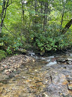
This stream, on my bucket list since I first started fishing these mountains, is easy to find on the map. I identified it by its geography before I knew what it was, or its history. If you spend time studying a map of the Great Smoky Mountains National Park in search of places to catch wild trout, you can’t miss it. The map details three streams emptying into a large pool marking the beginning of a fairly major river system. It calls out to the explorer…”Come find me”.
Steeped in local folklore and legend, this stream has been explored for thousands of years by Native Americans and others. Its headwaters, remote and rugged, protected by thick vegetation, steep ridgelines, and deep gorges is rarely visited, even by locals. The journey alone requires miles of bushwhacking or hours walking through creeks, climbing boulders, and scaling waterfalls. Some say you would do it better with mountain climbing gear. It is no place for those unfamiliar with wilderness trekking. There are no “legal’ campgrounds within two miles of a large pool marking the confluence of its left, middle, and right forks. The trip from the nearest campsite to the pool is an exercise in terrain association, map reading and time management. Believe me, your GPS will not work.
My buddy, Barry Holcombe, and I planned the trip for months. We’d constructed detailed Google Earth maps complete with routes and terrain descriptions. Our gear was checked and rechecked. Our September departure date was chosen so we would not have to carry the extra weight of cold weather gear. I won’t bore you with the route we chose to our campsite. Let’s just say it is a moderately steep and rocky trail.
The campsite, considered decent by bloggers, was not ideal. The main site, carved out of the ground on a sloping, washed out perch between two ridgelines, had a major flaw. We discovered quickly that any amount of rain created a creek right through the middle of camp. We resorted to pitching our tents in a level spot we found further in the woods. A water source is close by so drinking water is not a problem. There’s pully system for your packs and food just up the hill from camp like most sanctioned GSMNP campsites require.
Our plan was to hike to our site, make camp, and eat dinner the first night. We would then choose our route based on terrain and weather then strike out the next day for the large pool fed by the confluence of three remote forks.
Rain began to fall shortly after dinner the first night and did not stop until after breakfast the next morning. From our research, we knew we did not want to set out on our trek or get caught in the deep gorge of the right fork in high water. Long or heavy rain of any sort equaled dangerous conditions. We had to make a decision.
The rain stopped shortly after 9AM. The water level of the spring we would travel down from our campsite receded quickly. The skies cleared and we made the decision to begin our journey. We gathered our gear and followed the spring down hill dropping nearly one thousand feet in elevation to its confluence with the right fork…the path to our destination.
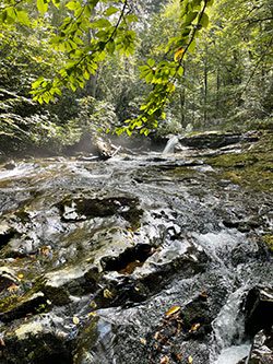
We waded, slid, and climbed down the spring to the larger creek. There were no discernable trails. After a half hour or so, we reached the right fork, tied a ribbon on a tree branch to mark our entry point, then took a left turn, continuing our journey down the middle of the creek, climbing down waterfalls and slick rock faces.
During my research, I read several accounts from fishermen and other hikers describing the rocks on the right fork as extremely slick. Usually, creek rocks at high elevations are easily walked with standard wading shoes or felt tip boots. This is not the case on this stream. The rock faces were downright dangerous and tested my water legs. Do yourself a solid and wear wading shoes with metal studs if you make this journey. The chance of a leg injury is significant and there is no easy way to get out.
We stayed in the creek for another two and a half hours before rounding the bend where it emptied into the big pool. We both stood there admiring the crystal-clear waters for several moments before crossing to the other side. We already knew that the creek we had just traveled down was worth a return fishing trip. We could spend a couple of days on it alone. We now discovered the left fork may have been a better destination. The middle fork, although small, probably held fish if you followed it up to some pocket water further up the mountain. There is just so much water to fish. Once on the right side of the pool facing downstream, we congratulated ourselves on the journey, ate lunch and geared up for what we knew would be an epic day of fishing.
The “good medicine” surrounding this stream is stronger than anything I’ve ever encountered in the Smoky Mountains. Maybe I built it up in my mind with my research and planning. I remember saying a prayer to the Creator of All Things. I asked for help with respect and patience and the ability to treat this water with all the reverence it deserved. I prayed for recognition of time and that I did not overstay my welcome. If you listen, you will be instructed.
In the first hole we fished, I caught a healthy, strong, and beautiful Southern Appalachian Brook Trout. I remember the colors of the fish were striking. The take was strong and confident like the fish had never experienced the danger of a stalking fly fishermen. I quickly released it back into the crystal water. Barry, who had crossed the creek just downstream, gave me a mental high five. We then paralleled each other down the stream to the next hole.
On my next cast, I broke my line on a Rhododendron branch. While tying on another fly, I noticed the glare on the water had grown dimmer. I looked up in the sky and dark clouds had rolled in over the mountains, blocking the sun from the deep river valley. While walking to another hole, the Great Spirit, answering my prayer, sent a rain drop directly into my eye.
Barry and I made eye contact, aware that we were in trouble if we did not leave immediately. I’m not saying we were frantic, but we quickly broke down our fishing rods and readied our gear for the journey back to our campsite. In total, we’d fished for roughly fifteen minutes.
With our gear secured, we made our way back up to the large pool, waded to the right fork, stopped briefly to pay our respects then turned sharply up the creek. Five minutes into the journey, the sky opened up. Ten minutes later, the creek we had walked down just one hour earlier, never encountering water past our knees, was at our waist. Fifteen minutes later, we were fighting rushing, chest-deep water.
We climbed water falls with the water square in our faces. At one point, I lost my footing and washed down a slick rock surface twice before making it back to my feet. It was quite funny, and I remember laughing out loud at its absurdity. Barry didn’t see me do it as he was busy negotiating a raging waterfall that stood in our way. I’m sure I would have never heard the end of it if he had. I watched him trying to find a way around the falls without success. He turned to me just as I regained my footing as if to say, “What do we do now?”. We began searching for a way out of the water but the ridgelines on each side were so steep that climbing out was impossible.
We were in trouble.
In unison, Barry and I realized we had no choice but to continue up the raging creek. Adrenaline kicked in; not that it had not already been there. We climbed the falls. In the military, we sometimes referred to these situations as “Embracing the Suck”. Time stood still. Even though the next part of the journey took over an hour, it felt like only a few moments.
We reached the ribbon tied on the tree branch marking our entry point to the small spring we’d climbed down earlier in the day. We’d been extremely fortunate. One missed step or injury could have been a disaster. We then climbed the steep branch and made it back to our campsite, soaked to the bone, bruised, and exhausted. While we were gone, the wind and rain had knocked down the shelter protecting our site. We repaired the damage, fixed dinner then retired to our tent to wait out the rain.

Our plan was to spend another two days exploring other routes leading to this remote area, but the rain had other plans. We broke camp the next morning and walked out in the rain. Our gear was soaking wet and much heavier, making the rocky and slick trail even harder to negotiate. The tension broke somewhat as we neared our truck. I began to relax a bit. About a quarter mile out, I stepped over a tree that had fallen across the trail. My front foot slipped in the mud and my back knee buckled. I limped into the parking area, but the damage was done. It’s been five months since the trip and my knee is just now getting back to normal; I still don’t trust it.
This adventure, if you decide to take it, is not for the casual hiker. It requires planning, the right equipment, and a confidence in your abilities. It also requires a certain reverence to the Spirit, palpable in every step you take in its waters and valleys. I’m positive that if you allow yourself to listen, it will speak to you.
In retrospect, and I think Barry agrees with me, our trip, although shortened by weather and riddled with danger, was the most exciting trip I’ve ever undertaken in our mountains.
We will go back.
Hopefully the WPPP will cut me some slack for telling this story.
Joe Woody is Co-Publisher of The Angler Magazine with his wife Debra. He is an Army Veteran and a self proclaimed “Adventure Angler”. You can usually find him wandering around Western North Carolina telling fishing lies. He is also a baseball nut and a crazy FCS Football fan. He has a Bigfoot magnet on the back of his truck.