 A ten-mile section of the Saluda River in Lexington and Richland Counties, from below Lake Murray Dam to the confluence with the Broad River, was designated a State Scenic River in 1991.
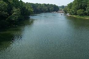
The Saluda Scenic River (commonly known as the “Lower Saluda”) is recognized as an outstanding recreational resource. The tailrace waters from Lake Murray reservoir provide a cold water fishery and varying river flows for recreational boating. Popular activities on the lower Saluda includes fishing for trout and striped bass, whitewater and flatwater paddling, and tube floating.
Partners for the Lower Saluda Scenic River Project serve on a local advisory council, which represents local landowners, river users, community interests, and SCDNR. Participation has included Trout Unlimited, Riverbanks Zoo and Garden, SCPRT (Dept. of Parks, Recreation and Tourism), River Runner Outdoor Center, SC Electric and Gas Company, Irmo-Chapin Recreation Commission, Palmetto Paddlers, Congaree Riverkeeper, Shaw Industries, American Whitewater, American Rivers, and The River Alliance.
Management plans for the river include the 1990 Lower Saluda River Corridor Plan and the 2000 Lower Saluda Scenic River Corridor Plan Update.
Go to the Lower Saluda Corridor Planning Project Page to see plan documents. https://www.dnr.sc.gov/water/river/scenic/lowersaluda.html
Recreational Access
There are currently four public access points on the Lower Saluda River. See the river map to get your bearings.
Hope Ferry landing (on south bank) and Saluda Shoals Park (north bank) – These provide the only public ramps for trailered boat launches on the river. Hope Ferry landing is accessed from Corley Mill Road which connects with SC Hwy 6 and US Hwy 378.
Saluda Shoals Regional Park – Open daily, admission fees are charged. River access facilities include a boat ramp, canoe launch, decked overlook to the river, and miles of nature trails along the river. Enter the park from Bush River Road which connects with SC Hwy 6 and I-20.
Gardendale/SCE&G Put-in – This access is 3.5 miles downstream from Hope Ferry and Saluda Shoals Park. The site provides access for boats that can be carried in. The location is on the north bank near the Gardendale community and Rivers Edge Retreat off Garden Valley Road which is accessed from Bush River Road near I-20.
Riverbanks Zoo and Botanical Gardens – Open daily, admission fees are charged. With entrance to Riverbanks, you can enjoy zoological and botanical exhibits, nature trails and a pedestrian bridge with views of Mill Race Rapids, historic structures, and more within the property. Riverbanks is located off Greystone Blvd which connects with I-126. NOTE: public access for river use (paddling, fishing, swimming) is no longer provided from the Zoo parking lots.
Going the Distance – Boaters can run the entire Lower Saluda through its confluence with the Broad River by taking out at landings on the Congaree River. Two carry-in boat access sites are located immediately downstream of Gervais Street Bridge (US Hwy 1), one on the east bank at Senate Street and one on the west bank at the amphitheater. Gervais Street Bridge is 10 miles downstream from Hope Ferry and Saluda Shoals Park. Public landings with ramps are located 2 and 3 miles downstream of Gervais Street Bridge on the east and west banks of the Congaree.
Safety Considerations
Water conditions on the Lower Saluda River can be Dangerous to all river users. Before using this river be aware of:
- Rapidly changing water levels
- Strong currents
- Cold water
- Large rapids
Consider the following
Lower Saluda River conditions and precautions:
- Water flow conditions can change rapidly within a couple of hours because of releases from the hydroelectric power facility at Lake Murray. Daily river flows may range from 400 to 20,000 cubic feet per second. Daily river levels may range from 2 to 10 feet.
- The river water is cold, about 60 degrees F, because it comes from deep within Lake Murray. Swimmers can experience hypothermia, even in the summer.
- Major rapids, up to Class V, begin downstream of the I-26 bridge. Many rapids have large hydraulics.
- All river users who are boating, swimming, or wading should wear life jackets.
- Mill Race Rapids Should Be Portaged. Walk Around It! A portage trail begins in a power line right-of-way just upstream of Mill Race Rapids on the right bank (south side) of the river.
Water Levels
Water flow in the Lower Saluda changes all the time. For the latest information check the following sources:
- S.C. Electric and Gas Company
- U.S. Geological Survey – South Carolina stream-gaging stations: https://waterdata.usgs.gov/sc/nwis/current/?type=flow
Look for two stations:
– Saluda River Below Lake Murray Dam
– Saluda River Near Columbia, SC
Contacts
For additional information about the Lower Saluda Scenic River Project contact: Bill Marshall, South Carolina Department of Natural Resources, P.O. Box 167, Columbia, SC 29202, Telephone: (803) 734-9096. https://www.dnr.sc.gov/water/river/scenic/saluda.html