by Alan Ritchie
All mariners that use the waters in southwest Florida are aware that conditions are dynamic and are constantly changing and local knowledge of current navigational issues is essential for safe boating in these waters.
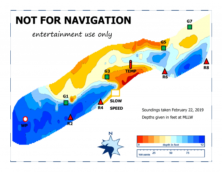
The technology on creating depth analysis for local waters is getting better each year. Some of the larger vessels using Wiggins Pass have equipment on board that include forward-looking sonar and the ability to create a graphical plot of the water depths of their routes. These vessels know where the deeper water is or isn’t. On a regular basis, the Estuary Conservation Association, Inc. does depth soundings and post the results on their website at www.estuaryconservation.org. This information in not intended for navigation primarily because it represents conditions at a single point in time (when the sounding were taken) and is not a forecast of what to expect in the future. While limited, looking at multiple soundings over time does help boaters to adjust their route in the waterways to operate their vessel in areas of deeper water.
Since the last dredge in Wiggins Pass, conditions have been good. The post-dredge channel has been navigable and well-marked. The County added a floating red marker on the south side of the channel to mark some shoaling coming off the Delnor-Wiggins State Park beach. This shoaling has continued since February 1st particularly around marker G3 and it appears that the deeper water now exists to the north side of marker G3.
The County has been notified and a request has been made to consider moving the G3 marker farther to the north. This change is under review and changes are expected soon, By the time you read this report, the floating red marker and Green 3 should be re-located.
The new depth technology creates new navigation challenges. If one boater has the sounding information and the other does not, operating in narrow, heavily used waterways, can be a real challenge! If a boater is relying on just the channel markers, he or she will expect the other boats in the area to do the same. In this situation, the best approach is to standby and wait until you have no other boat traffic the channel so you are not forced by oncoming traffic into areas of shallow water where you don’t want to be.
To get regular, up-to-date information on what’s happening in Wiggins Pass, check out the ECA website regularly at: www.estuaryconservation.org and then be very patient when using Wiggins Pass. A printed copy of the ECA sounding are also posted at the gas dock at the Cocohatchee Marina,
Safe Boating!