By Alan Ritchie:
Navigating the Wiggins Pass Channel this summer has been challenging as the deeper water has continued to move northward leaving the depths in parts of the marked channel below 3 feet at mean low water.
As a result, operating your vessel safely in the area requires all mariners to take the time to understand the changing conditions in the pass, knowing what is occurring, and taking appropriate action. Wiggins Pass is, and always has been, subject to continuous shoaling… that’s the “bad news”. The “good news” is that information on the water levels in the pass is readily available if you know how to obtain it!
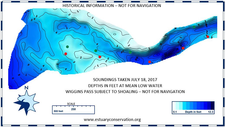
For the past 18 months, the Estuary Conservation Association, Inc. (ECA), a local North Naples based non-profit, has been monitoring water depths in and around the marked channel to study the changes in the shoaling conditions. They take this information, adjust the measurements to reflect the estimated water depths at “mean low water” and make this information available to the public without charge. Because this information is based on historical data, it is clearly not a forecast and is made available with a clear disclaimer that it is not to be used for navigation. In spite of this significant limitation, it does provide mariners with a general idea of the conditions that are likely to be encountered.
This information is available in two convenient places. It is posted regularly on the wall just inside the fuel dock office next to the boat ramp at the Cocohatchee Marina. It is also available on the ECA website at www.estuaryconservation.org. The advantage of the website is that you can look at the changes over time to get an idea of the direction and velocity of the changes over time.
Below, you will find a diagram of the Wiggins channel and the measured depths on July 18, 2017. This is essentially a snapshot of the conditions in the channel at the exact time the measurements were taken…and therefore is not a forecast of future conditions.
Because the better water is continuing to migrate to the north, Collier County is in the process of relocation the channel markers in the pass to improve that aid to navigation. Those changes should be completed in mid-August and new soundings will be available after the markers are moved.
Safe boating! – 8/9/17 – AJR
Alan Ritchie is a volunteer member of the Board of the Estuary Conservation Association, Inc.